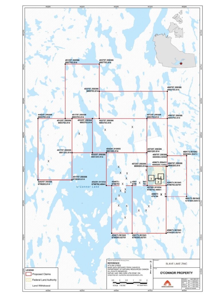
Expanded Land Package
WHY WE STAKED
Flyover
The image that is on this page shows the extent of the 900-line km that Slave Lake Zinc flew with modern geophysics.
The image is for reference as the data is proprietary and can be viewed after a Non-Disclosure Agreement (NDA) is signed with the company. The survey covers most of the known historic showings within our area of interest
Many of these quartz veins are several kilometers apart and have non-compliant historic zinc and lead assays as high as those sampled at the head frame area and the MWK#1 vein. Many of the showings also have significant precious metals content, not commonly assayed for in the early days. “If you couldn’t see it, why assay for it?”
This of course will be our first and most important immediate job to cover the area with a crew capable of re-discovering these showings and probably finding many more as the areas between historic showings appear to have never been physically covered.
(It should also be noted that Slave Lake Zinc has a current Water License and a permit for a 49-man camp and drilling.)
Expanded LAND package
The expanded land package is approximately 76.25 square kilometers. This is 15 plus times our original lease. This was needed as the company (SLZ) was aware of a significant number of historic showings that appear to have only been mapped from the shoreline of the nearest water body. A quote from an old-time prospector seems to apply:
“As far as I could throw my hammer from the boat (or canoe)”
We (SLZ) were also aware of work that was done after the mine site was closed by a Mr. Bansi Prusti who spent 1953 and 1954 on the map area constructing his doctoral thesis on the minerology of the area and showings surrounding the O’Connor Lake mine site. Mister Prusti did become Doctor Prusti after his dissertation and thesis were read. (Dept. Of Geological Sciences, McGill University, Montreal)
With emphasis on his mineralogy and chemistry Slave Lake Zinc is confident that the science available to Dr. Prusti at that time was of sufficient quality to be able to establish credence in Dr.Pusti’s conclusions.
We (SLZ) also were fortunate to have access to significant historical documentation from several of the claim holders from the 50’s who later let their claims lapse prior to the Land Withdrawal of the 1990’s. Thanks to our Geologist/Director, Glen Macdonald, whose knowledge of O’Connor Lake and surrounding area we were able to confidentially establish the primary areas that Slave Lake needed to acquire.
It should be noted that Mr.Macdonald’s father worked for American Yellowknife Mines, the owner of the O’Connor Lake mine.